Skip to content

DirectorySkills

Illustrated city maps: sheet, made in this run
Run 1Illustrated city maps“Make an illustrated map of our village fair”
Runs in
  • Claude Code
  • Codex
  • Cursor
  • Gemini CLI
  • GitHub Copilot
  • OpenCode
Generates with
Your agent's modelFLUX.2 [dev]falFLUX.2 klein 9BCloudflare Workers AI
Tested with
Claude Code 2.1.322Claude Sonnet 5.51 real run, 10 Nov
Needs
Node 20+ChromeA fal or Cloudflare Workers AI key
Licence
Recaply licence

Illustrated City Maps

Bird's-eye illustrated city maps with little landmark buildings and place names set in real type.

$9.99once, yours to keep

Makes illustrated city maps: a bird's-eye watercolour city with cream streets, green parks, blue water and small landmark buildings. Place names and the title are set in type at the points you choose, so they are always spelled right. Drawn by a picture model with any words set in real type afterwards, so spelling is exact. Needs a FAL_KEY or a Cloudflare Workers AI key; about $0.01 to $0.02 a picture. Use when someone wants an illustrated or tourist map of a town or area, a map for an event or guide, or a hand-drawn style city map.

By RecaplyUpdated 11 Nov

Install Illustrated City Maps

After the download, ask your agent to add it, or run the line yourself.

Read https://recaply.co/skills/illustrated-city-map/install.md and follow it to install the illustrated-city-map skill from illustrated-city-map.zip.

Paste it into your agent. It reads our install steps, finds the ZIP you downloaded and adds the skill for you.

New to skills? How to install a skill

Similar skills

All 735 skills

Who Illustrated City Maps is for

What you get

  • 1 map, drawn as one matching set
  • Place names and the title are set in type at the points you choose, so they are always spelled right
  • Every word set in real type, so spelling is exact

Good fit

  • Tourism
  • Guides
  • Events

Not for

  • Pictures of real people, or photos of your real product
  • Copying a living artist's or a brand's style

About this skill

You say

Make an illustrated map of our village fair

It said back

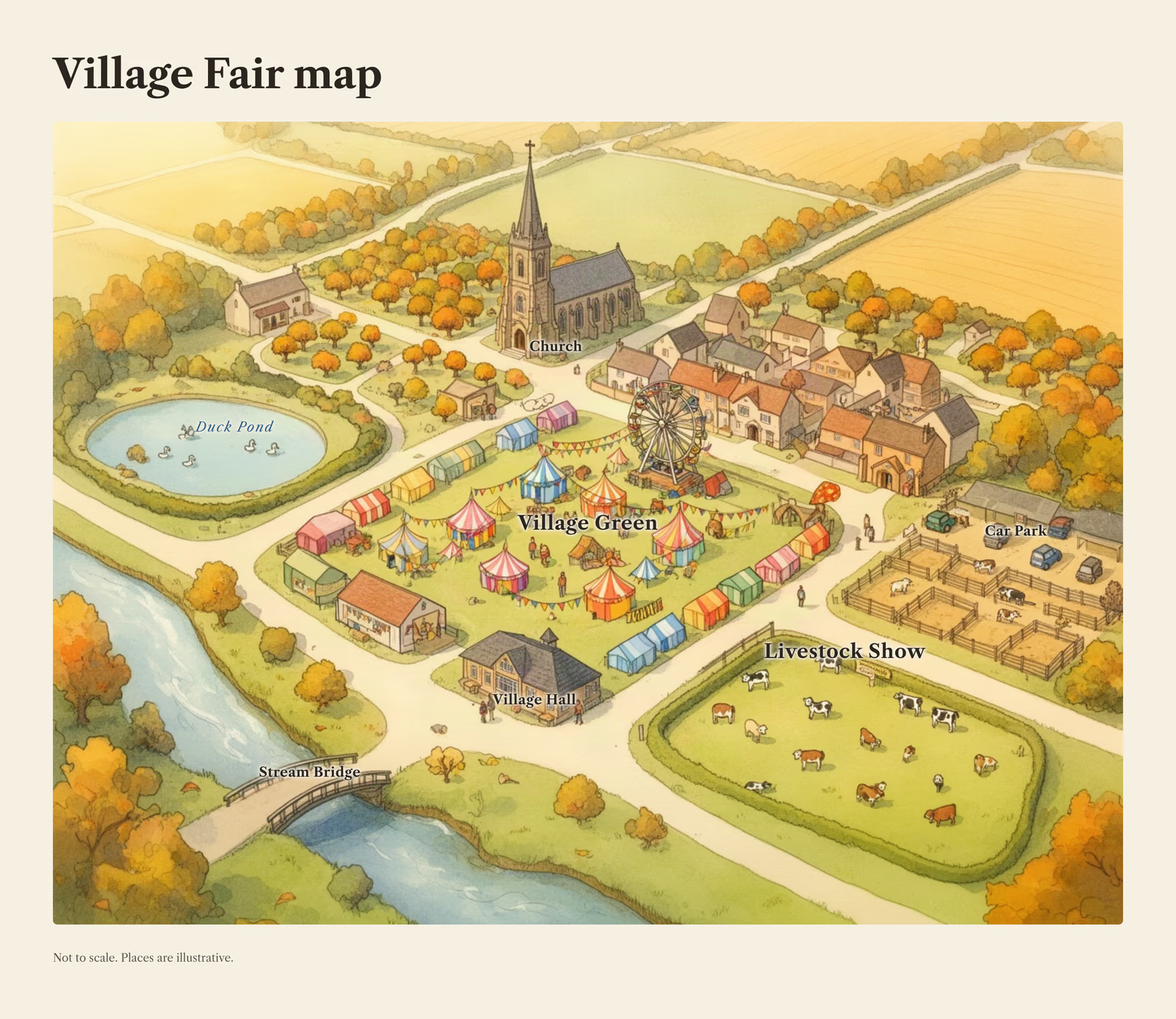
Your illustrated village fair map is done: a bird's-eye watercolour village with a fair on the green, with the names set in real type.

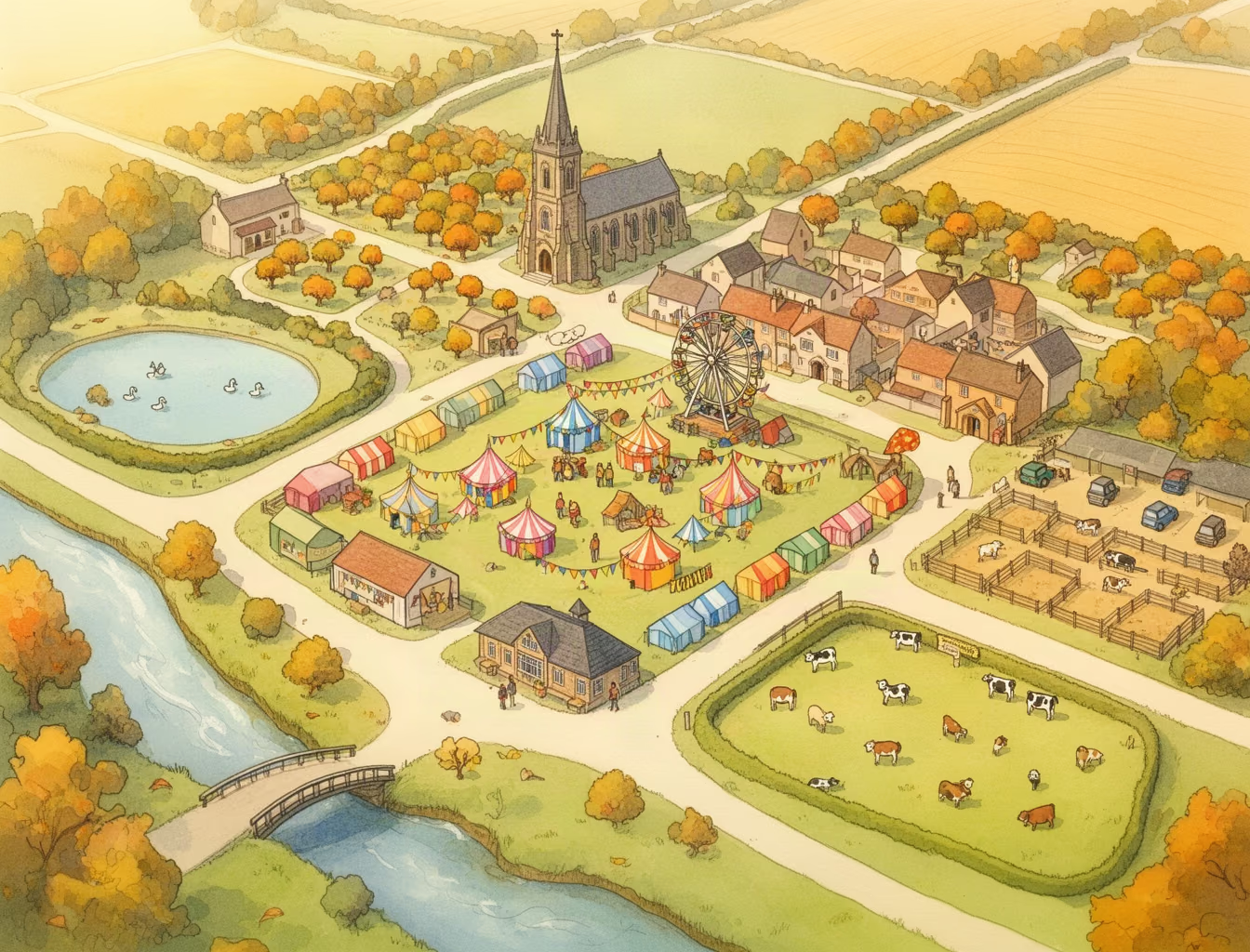
I'd no details about your actual village, so I drew a generic English one. The layout is a village green full of fair tents and a ferris wheel, a church to the north, a duck pond to the west, a stream with a bridge to the south, and a livestock field and a car park to the east. The seven labels sit on those spots: Village Green, Church, Duck Pond, Livestock Show, Village Hall, Car Park and Stream Bridge. The footer says "Not to scale. Places are illustrative."

Show more

What it did in run 1

  1. illustrated-city-map
  2. node .claude/skills/illustrated-city-map/scripts/check.mjs
  3. mkdir -p village-fair && cd village-fair && cat > plan.json <<'E' { "style": "city-map", "bible": "early autumn village fair, warm golden light, bunting and colourful tents, no text anywhere", "items": [{"name":"map","subject":"a small village seen from above with a village green in the centre filled with fair tents and a ferris wheel, a stone church with a spire to the north, a pond with ducks to the west, a duck-free stream running along the south, a livestock show field with pens to the east, a car park meadow at the south-east, a small bridge over the stream, a village hall near the green, winding lanes, orchards and fields around the edges"}], "labels": [ {"text":"Village Green","x":50,"y":48}, {"text":"Church","x":48,"y":18,"size":"s"}, {"text":"Duck Pond","x":18,"y":45,"kind":"water","size":"s"}, {"text":"Livestock Show","x":80,"y":45}, {"text":"Village Hall","x":36,"y":62,"size":"s"}, {"text":"Car Park","x":80,"y":78,"size":"s"}, {"text":"Stream Bridge","x":50,"y":82,"size":"s"} ], "sheet":{"layout":"map","title":"Village Fair map","footer":"Not to scale. Places are illustrative."} } E node ../.claude/skills/illustrated-city-map/scripts/picture.mjs plan.json; cat costs.json | tail -5
  4. ./village-fair/pictures/map.png
  5. ./village-fair/plan.json
  6. cd village-fair && node ../.claude/skills/illustrated-city-map/scripts/picture.mjs plan.json; tail -8 costs.json
  7. ./village-fair/pictures/map.png
  8. ./village-fair/sheet.png
  9. node -e ' const f="plan.json",p=JSON.parse(require("fs").readFileSync(f)); const m={"Village Green":[50,50],"Church":[47,28],"Duck Pond":[17,38],"Livestock Show":[74,66],"Village Hall":[45,72],"Car Park":[90,51],"Stream Bridge":[24,81]}; p.labels.forEach(l=>{[l.x,l.y]=m[l.text]}); require("fs").writeFileSync(f,JSON.stringify(p,null,2));' node ../.claude/skills/illustrated-city-map/scripts/picture.mjs plan.json --sheet-only
  10. ./village-fair/sheet.png
  11. Done

10 Nov 2026 · Claude Code 2.1.322 with Claude Sonnet 5.5 · 1 min 10 s · $0.14 of API use

Questions

Is Illustrated City Maps free?

No. Illustrated City Maps costs $9.99 once and stays in your Recaply account, or it comes with the Recaply plan ($19.99 a month), which opens every premium skill and prompt.

Which agents can use Illustrated City Maps?

Claude Code, Codex, Cursor, Gemini CLI, GitHub Copilot and OpenCode.

What do I get when I buy Illustrated City Maps?

A ZIP of the whole skill folder (20 KB): the SKILL.md your agent follows and its 4 other files, the references, templates and scripts it uses. You download it from this page whenever you need it, and install it in Claude Code, Codex, Cursor, Gemini CLI, GitHub Copilot and OpenCode. The Recaply plan opens it too, with every other premium skill and prompt.

How do I install Illustrated City Maps?

Buy it, then download the ZIP from this page. For Claude Code, unzip it into .claude/skills/ in your project. For Codex, Cursor and Gemini CLI, unzip it and run npx skills add ./illustrated-city-map with your agent's flag.

What do I get from Illustrated City Maps?

1 map, drawn as one matching set. Place names and the title are set in type at the points you choose, so they are always spelled right. Every word set in real type, so spelling is exact.

What does Illustrated City Maps need?

Node 20+, Chrome and a fal or Cloudflare Workers AI key (it reads FAL_KEY). Each use costs about $0.01 to $0.02 a picture.

How big is Illustrated City Maps?

5 files, about 12,320 tokens in all. The SKILL.md is about 2,129 tokens, and your agent reads it only when the job fits.

What does a run cost?

Our 1 runs took 1 min 10 s to 1 min 10 s and $0.14 to $0.14 of API use each, in Claude Code with claude-sonnet-5-5. On a Claude plan, a run counts toward your usage instead.

Do I have to name Illustrated City Maps to use it?

Type /illustrated-city-map first to make sure it loads. Without it, Claude Code may judge a small job simple enough to do without the skill.